
The San Diego weather that has enveloped Ohio for the past month – warm days and cool nights with no rain – has been a comfortable dream for many.
But it’s increasingly uncomfortable for farmers and some who supply water to thousands of Ohioans.
August was the driest in recorded history in Ohio, according to the State Climate Office, and the state is now in the longest dry spell ever – with less than an inch of rain in the past 49 days.
That could change this weekend, when the National Weather Service predicts at least a 50% chance of rain in Licking County each day from Sunday night, Sept. 21, through Tuesday, Sept. 23.
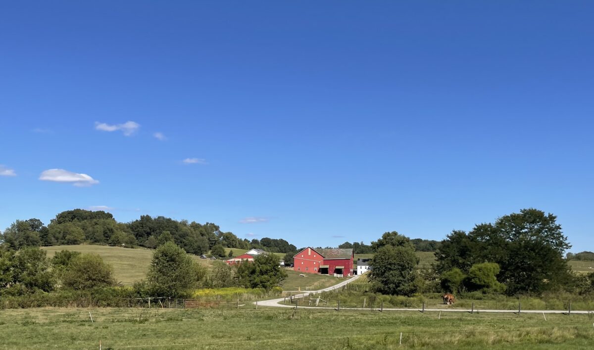
Pastures are parched and brown. Crops are dying in the field. And some farmers are hauling water to pastured cattle again – for the second year in a row because of a severe drought the state experienced in 2024.
“Every drought is different, said Aaron Wilson, State Climatologist of Ohio and an assistant professor at Ohio State University. “This drought, instead of getting dry in June and staying that way through July, August and September – this one came on rapidly.
“We saw a tremendously wet April through July, with very high humidity through June and July, and then we went to the driest August on record in over 131 years,” Wilson said.
The effects are appearing rapidly, he said.
“Soybeans need rain in August to help fill pods, and it wasn’t there,” Wilson said. “There’s some concern – not panic – over soybeans. Having between 22 and 28 days of rain in May delayed planting until June. And where we had late-planted crops combined with a dry August – some of those just died. They never reached maturity.”
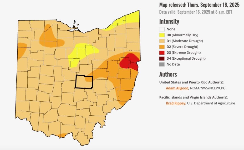
The latest U.S. Drought Monitor, released on Thursday, shows that “drought conditions continue to worsen across all of Ohio,” the State Climate Office reported. “Approximately 2% of the state has now been moved to D3-extreme drought conditions. Approximately 14% of the state has been moved to D2-severe drought, with D1-moderate drought now encompassing nearly the entire state.”
Carroll, Columbiana, and Jefferson counties, in far eastern Ohio, are most affected by the move to extreme drought conditions.
Most of Licking County is experiencing moderate drought conditions, but the northeastern townships are in severe drought.
“It’s pretty bad,” said Dean Kreager, educator for agriculture and natural resources at the Ohio State University Agricultural Extension Service Licking County office in Newark. “Last year, the southeast corner of the county was hit hard – but not as bad this year. This year, it’s the northeast corner and north-central part of the county.”
He has heard from farmers who are hauling water to their livestock and some who are feeding hay because “their pastures are burned up.”
Statewide, “agricultural impacts continue to expand, and landscape impacts – including tree and lawn stress – are evident,” according to Ohio State University’s drought resource webpage for farmers. “The forecast for the next seven days shows a chance of showers for Sept. 21-23 … but confidence remains low, and rainfall totals are likely to still be below average for the week.”
Wilson said his office has had reports of farmers hauling water to their animals in Guernsey and Morgan counties. And in parts of the state, farmers are feeding hay to their animals months before they normally would do so because their pasture grass has dried up and turned brown.
“They’re now using hay they would normally save for winter,” he said, noting that some of them did the same last year, which means they could face a hay deficit going into this winter.
With two drought years in a row, there is also concern about lack of moisture in the soil and about whether underground aquifers are recharging as they would during periods of normal rainfall.
| Read more: A wet end to 2024 assures that the drought is over in Licking County and most of Ohio
He said that at least two water systems north of Columbus – Del-Co and Aqua – have implemented water restrictions.
Licking County is now 4 to 5 inches below average rainfall since Aug. 1.
“We’re seeing a very rapid intensification of drought across the state, particularly with this week’s hot weather,” Wilson said. “The drought conditions are working very quickly.”
He’s hopeful that Ohio will see rain in the coming days.
“We need to get three-quarters of an inch per week to be normal,” Wilson said.
Looking at the forecast, he said it looks like the bulk of the rain predicted for Sunday night through Tuesday would fall on Tuesday, which means it would not be included in the Drought Monitor report that comes out next Thursday.
He said it looks like Licking County could see in the neighborhood of a tenth to a quarter inch before Tuesday, “so we could see some further degradation” in the next drought report.
And for as much as he’d like to see rain, “we don’t want too much at once like last year with the remnants of Hurricane Helene.
“Too much at once, and the first quarter of an inch might sink in, but on poor soil or really hard ground, a high participation rate could just run off.”
Here is the National Weather Service forecast for most of the coming week:
Friday night: Mostly clear. Lows around 60. Northeast winds around 5 mph.
Saturday: Partly cloudy. Highs in the upper 80s. East winds around 5 mph.
Saturday night: Partly cloudy in the evening, then clearing. Lows in the lower 60s. Southeast winds around 5 mph.
Sunday: Partly cloudy. A slight chance of showers in the afternoon. Highs in the mid 80s. South winds 10 to 15 mph. Chance of rain 20 percent.
Sunday night: Showers likely. Lows in the lower 60s. Chance of rain 60 percent.
Monday: Mostly cloudy. A chance of showers in the morning, then a chance of showers and thunderstorms in the afternoon. Highs in the upper 70s. Chance of rain 50 percent.
Monday night: Showers likely with a chance of thunderstorms. Lows in the lower 60s. Chance of rain 60 percent.
Tuesday: Partly cloudy. A chance of showers in the morning, then a chance of showers and thunderstorms in the afternoon. Highs in the upper 70s. Chance of rain 50 percent.
Tuesday night: Partly cloudy with a chance of showers and thunderstorms in the evening, then mostly cloudy with a chance of showers after midnight. Lows in the lower 60s. Chance of rain 50 percent.
Wednesday: Mostly cloudy. A chance of showers. Highs in the mid 70s. Chance of rain 30 percent.
Wednesday night: Partly cloudy. A chance of showers. Lows in the upper 50s. Chance of rain 30 percent.
Thursday: Partly cloudy. A chance of showers in the afternoon. Highs in the mid 70s. Chance of rain 30 percent.
Alan Miller writes for TheReportingProject.org, the nonprofit news organization of Denison University’s Journalism program, which is supported by generous donations from readers. Sign up for The Reporting Project newsletter here.